

Marine Ways
Kernalite
Marine navigation is one of those jobs where a small delay or a cluttered screen can become much more frustrating than it would on a normal road trip. I spent time looking at Marine Ways from that practical angle: how quickly it gets from opening the app to useful chart information, how it behaves when planning a route, and whether it feels dependable enough to keep nearby on the water. My overall impression is that this is a focused Travel & Local app for people who want nautical charts, route planning, and GPS-guided marine navigation without starting with a complicated professional system.
Marine Ways is free to install, developed by Kernalite, and aimed at everyone rather than a specialist age group. It has built a respectable audience, with a 4.6 average from around 2.3 thousand ratings and more than 100 thousand installs. Those figures do not replace personal testing, but they do suggest that the app has found a useful place among recreational boaters and people who need marine map information on a mobile device.
How Marine Ways feels when you actually use it
Getting from launch to a usable chart
The first thing I value in a navigation app is not visual polish; it is the distance between opening it and understanding where I am. Marine Ways is built around a clear marine-navigation purpose, so the experience feels more direct than using a general map application and trying to interpret waterways, shorelines, and boating routes through a road-focused interface. That focus matters when I am thinking about a harbor entrance, a planned crossing, or the relationship between my position and a water route.
Its main appeal is the combination of chart viewing, route planning, and GPS guidance in one place. Instead of switching between a chart source, a separate route sketching tool, and a phone’s ordinary location map, I can treat the app as a single planning surface. That does not make every trip automatically safe, but it reduces the mental work involved in preparing a simple outing.
Speed is best understood here as workflow speed rather than a stopwatch result. A lightweight route adjustment or a quick look at the chart should feel more immediate than rebuilding the same plan across several unrelated apps. The app’s focused design helps with that. On the other hand, marine charts can contain a lot of visual information, so the experience naturally depends on how much area I am viewing and how detailed the map becomes. I would not judge it like a casual weather widget that has almost nothing to draw.
Related News

Why WhatsApp Messenger Still Makes Everyday Communication Feel Easy

Jurassic World: The Game Is the Better Dino Tycoon for Strategic Players

Threads in Real Life: Who Should Join, Lurk, or Leave

How SHEIN Turned Shopping Into an Endless Content Feed

How to Make Fortnite Feel Smarter on Mobile

Should You Switch to Microsoft Outlook on Mobile?
Planning a route without overcomplicating it
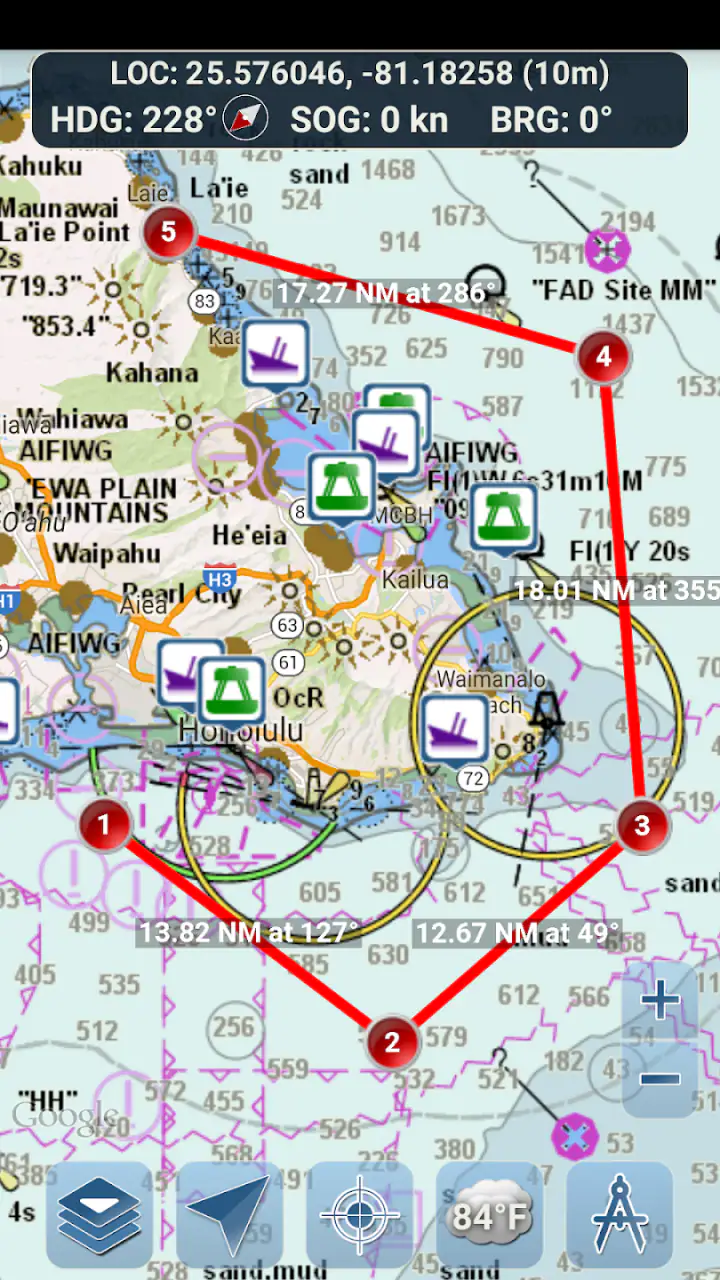
Route planning is where Marine Ways becomes more useful than a basic map app. I can think through a trip before leaving, inspect the intended direction, and use the phone’s position as a reference while moving. That is especially helpful for a boater who knows the general destination but wants a clearer picture of the water journey between departure and arrival.
One practical habit is to plan while stationary, with the phone charged and the route considered before casting off. I prefer making the broad decisions at the dock rather than trying to build a route while handling a boat. The app can support that preparation, but it should not encourage anyone to treat a phone screen as a substitute for observation, local knowledge, or proper marine equipment.
A less obvious strength is the way route planning can expose uncertainty before the trip begins. A line that looks simple at a wide zoom may feel very different once I examine the surrounding waterways more closely. I use that change in perspective as a prompt to reconsider the route, check conditions separately, and decide whether the planned trip is suitable for the boat and crew. In that sense, the app is most valuable before navigation starts, not only during the journey.
Gallery
What happens during a busy navigation moment
The heavier moments are not necessarily caused by one dramatic feature. They come from combining chart movement, route inspection, and GPS-guided navigation while I am also trying to pay attention to the real environment. That is when a phone app has to remain understandable. Marine Ways benefits from having a narrow purpose, because I am not asking it to manage hotel bookings, road traffic, restaurant searches, and boat navigation on the same screen.
Still, a mobile device has limits. If I zoom, pan, change the route, and keep checking my position repeatedly, the experience becomes more demanding than simply looking at a fixed chart. I would keep the route as settled as possible before moving and avoid unnecessary screen interaction while underway. That is both a performance-minded habit and a sensible safety habit.
For a realistic everyday scenario, imagine a short weekend trip from a familiar marina to a nearby anchorage. Before departure, I would open Marine Ways, review the chart, outline the route, and confirm that the planned direction matches what I expect from the water around me. During the trip, I would use GPS guidance as a reference rather than stare continuously at the display. If the plan changed, I would make the adjustment when safely stopped or when another person could handle the device.
Stability and recovery when something goes wrong
Reliability in a navigation app is more than whether it opens successfully. I also care about how easily I can recover after leaving it, changing applications, losing track of the route screen, or needing to rethink the journey. Marine Ways makes the most sense when I treat it as part of a prepared workflow: open it before departure, check the route, keep the device ready, and avoid relying on last-second improvisation.
I would not build a boating plan around the assumption that any phone app will always be available in exactly the state I left it. Phones can be bumped, batteries can run low, and attention can be diverted. My practical approach is to keep a backup way to understand the trip and to know the route well enough that reopening the app is a convenience rather than a rescue plan. That is not a criticism unique to this product; it is an important distinction between digital assistance and primary seamanship.
Marine Ways is more convincing as a planning and secondary navigation aid than as the only instrument on a serious voyage. If I were heading into unfamiliar waters, dealing with poor visibility, or making a trip where failure would have serious consequences, I would want dedicated marine equipment and another person capable of navigating. The app can still be useful in that setting, but I would not give it responsibility beyond what a phone-based tool can reasonably carry.
Device demands and practical phone limits
The listed minimum operating-system requirement is 10, which makes the app accessible to devices that are not necessarily brand new while still setting a clear boundary for compatibility. Before installing, I would check that the phone meets that requirement and has enough battery capacity for the planned outing. A phone that is technically compatible but already warm, nearly empty, or difficult to see outdoors is not a dependable navigation device.
Screen size also changes the experience. A larger display is more comfortable for examining a route and keeping nearby chart details visible. A smaller phone can remain useful for a quick position check, but it makes detailed planning and repeated panning less pleasant. I would rather plan on the largest practical screen available and use the phone in my hand only for concise checks once underway.
Resource demands are difficult to separate from the device and the amount of chart activity. Viewing a simple area should be less demanding than constantly moving around a broad region and repeatedly changing the view. My advice is to close unrelated apps, reduce unnecessary screen use, and start with a well-charged phone. A vehicle charger or power bank is sensible for longer outings, although it should be secured so it does not create its own problem on board.
The app’s current version is 1.99, and its long presence on mobile stores gives it the feel of an established tool rather than a brand-new experiment. It was released on August 27, 2015, so the important question for a new user is not whether it is fashionable, but whether its navigation approach matches the way that person actually travels by water. I would install it on the intended device and test the complete planning routine before trusting it on an important trip.
Where it beats ordinary map alternatives
A standard road-mapping app is excellent for driving directions, addresses, and traffic-oriented travel, but it is not designed around the way a boater thinks about a water route. Marine Ways has a more appropriate context because its core job is marine charts, route planning, and GPS guidance on the water. That specialization is the reason I would choose it over a general map for boating preparation.
Paper charts and dedicated chartplotters still have important advantages. Paper does not depend on battery power, and a chartplotter can be easier to read as a permanent part of a boat’s equipment. Those options also encourage a broader view of navigation rather than a phone held close to the face. Marine Ways wins on portability and convenience: it is easier to carry, easier to use for an occasional trip, and less expensive to try because the app itself is free.
There is also a middle ground between the app and professional navigation software. A dedicated marine package may offer a deeper collection of tools for experienced sailors, but it can require more time, money, and equipment than a casual boater wants to commit. Marine Ways is a better fit when I need a practical mobile starting point and understand that it is not the entire navigation setup.
What the free model means in practice
The app is free, but it includes in-app purchases priced at $1.99 per item. That makes the initial decision easy: I can try the basic experience without paying upfront, then decide whether an optional purchase is worthwhile for my use. I would not pay automatically just because I am planning a trip. I would first learn which parts of the app I actually use and whether the free experience already covers my normal route-planning needs.
This model is particularly suitable for occasional boaters who want to explore the interface before committing to a larger navigation setup. It is less ideal for someone who expects every advanced capability to be included at no cost or who dislikes making small purchases inside an otherwise free app. The sensible approach is to treat the free installation as an evaluation period and make any purchase only after testing the app on a familiar, low-pressure outing.
Who should use it, and who should look elsewhere
I would recommend Marine Ways to recreational boaters, travelers who spend time on waterways, and anyone who wants a mobile tool for studying marine routes before leaving shore. It is also a reasonable option for someone moving from ordinary map apps toward more boating-specific planning without immediately buying a dedicated navigation system.
I would be more cautious about recommending it as the sole navigation solution for offshore passages, difficult weather, unfamiliar and technically demanding waters, or trips where a device failure could put people at risk. In those situations, a chartplotter, current paper charts, a reliable backup, and proper boating knowledge matter more than the convenience of a free phone app.
It may also be the wrong choice for a user who wants a broad travel companion rather than a marine-focused tool. If the main need is road navigation, public transport, accommodation, or general destination discovery, a conventional travel app will be more suitable. Marine Ways earns its place when the journey itself is centered on water and the user is willing to take responsibility for interpreting the information.
My performance verdict after weighing speed and limits
Marine Ways feels most effective when I use it deliberately: prepare the route while stationary, inspect the chart at useful levels of detail, keep the phone powered, and use GPS guidance as support rather than as an excuse to stop paying attention. Its focused purpose makes the planning process more direct than adapting a road map, and its free entry point makes it easy to judge for myself.
Its limitations are just as important. A phone is still a phone, a small screen is not a full navigation console, and route guidance cannot replace local awareness or backup planning. Heavy interaction during a busy part of a trip is uncomfortable, and I would not want the app to become the only source of navigation information. Those trade-offs do not cancel its value; they define the situations where it should be used.
For me, the strongest case is short and medium recreational outings where I want a marine chart, a route plan, and a GPS reference in one portable app. The combination is practical, the age rating keeps it broadly accessible, and the solid user response gives it a credible starting point. I would download it for preparation and everyday boating support, then pair it with sensible equipment and judgment. The best way to use Marine Ways is as a clear, convenient layer in a larger navigation routine—not as the entire routine itself.
FAQs for Marine Ways
What is Marine Ways, and what can I use it for?
Marine Ways is a boating and marine-weather application designed to help users check conditions before and during a trip on the water. It can provide access to weather information, forecasts, radar or map-based data, and other useful details for boaters, anglers, sailors, and coastal travelers. Its main purpose is planning and awareness, not replacing proper navigation equipment or official safety guidance.
Does Marine Ways provide accurate marine weather and wind information?
Marine Ways can be a convenient source for checking marine forecasts, wind conditions, wave information, and changing weather patterns, but accuracy may vary depending on location, forecast model, data provider, and update timing. During testing, information was useful for general planning, although users should compare it with official marine advisories, local forecasts, and onboard instruments before making safety-critical decisions.
Can I use Marine Ways without an internet connection?
Marine Ways primarily depends on an internet connection to load current forecasts, maps, radar imagery, and other live marine information. Some previously viewed information may remain temporarily available through device caching, but users should not assume that the app offers complete offline navigation or updated weather data. Downloading charts, checking forecasts, and preparing a backup plan before leaving coverage is recommended.
Is Marine Ways suitable for navigation and emergency situations?
Marine Ways may support trip planning and situational awareness, but it should not be treated as a complete navigation system or an emergency communication tool. It may not replace nautical charts, GPS equipment, depth instruments, a marine radio, life-saving equipment, or official navigation notices. Boaters should verify hazards and routes using reliable onboard equipment and follow local maritime safety regulations.
Is Marine Ways free to download, and are there any additional costs?
Marine Ways may be available to download at no initial cost, although the exact pricing, advertising, premium features, or optional subscriptions can depend on the platform and current app version. Before installing, review the Google Play Store or Apple App Store listing for the latest details. Also check whether any in-app purchases are required for advanced forecasts, expanded maps, or an ad-free experience.
Pros
- Clear marine weather forecasts help with trip planning.
- Useful tide and current information for coastal activities.
- Map-based tools make locations easy to identify.
- Covers many boating and fishing destinations.
- Practical interface for checking conditions quickly.
Cons
- Some features may require an internet connection.
- Forecast accuracy can vary by region and data source.
- The interface may feel dated on some devices.
- Advanced tools may be limited compared with navigation apps.
- Not a replacement for official marine safety information.


